Texas, Oklahoma, and the Plains Brace for Bitter Sunday Morning as Arctic Front Drives Wind Chills Into the Teens and Below Zero
TEXAS AND OKLAHOMA – A powerful Arctic cold front sweeping through the region late Friday is setting the stage for dangerously cold wind chills early Sunday morning, with parts of Texas, Oklahoma, and the central Plains facing the harshest conditions of the winter season so far.
Forecasters say temperatures will plunge rapidly behind the front, with readings dropping as much as 25 degrees in North Texas by Friday, accompanied by strong winds of 35 to 45 mph. Those winds will play a major role in making conditions feel far colder than the thermometer suggests.
Wind Chills Plunge Across Multiple States
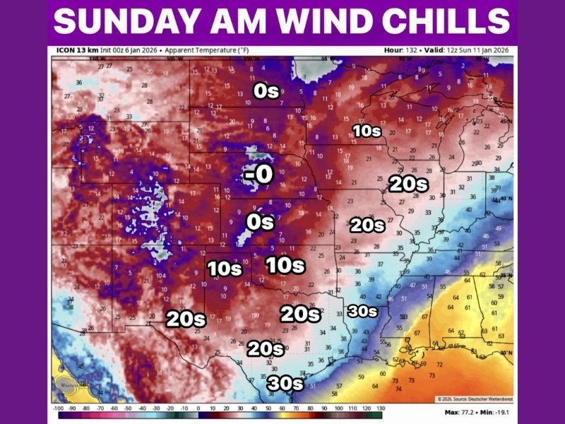
By early Sunday morning, widespread wind chills in the 20s are expected across much of Texas, with 30s extending into South Texas. North Texas will feel significantly colder, while Oklahoma drops into the teens, and parts of the central Plains experience wind chills near or even below zero.
The wind chill map highlights a sharp gradient, with the coldest apparent temperatures centered across the Plains and Midwest, spreading southward overnight. Even areas that avoid single-digit air temperatures will feel the sting due to relentless wind.
Why This Cold Hits Harder Than Usual
This is not a typical winter cool-down. The incoming Arctic air mass is dense, fast-moving, and reinforced by strong pressure differences, which is why winds remain elevated even after temperatures fall. That combination dramatically increases the risk of cold stress, especially for anyone outdoors early Sunday.
Unlike calm cold nights, windy Arctic outbreaks prevent surfaces, roads, and structures from retaining warmth, making the chill feel immediate and aggressive.
What Residents Should Prepare For
Officials urge residents across Texas, Oklahoma, and neighboring states to take this cold seriously. Prolonged exposure Sunday morning could lead to hypothermia or frostbite, particularly for children, elderly individuals, and outdoor workers.
Homeowners should also prepare for frozen pipes, especially in areas unaccustomed to sustained cold. Vehicles left outside may struggle to start, and pets should be brought indoors well before temperatures bottom out.
Timing: When Conditions Are Worst
The coldest wind chills are expected just before sunrise Sunday, when overnight cooling combines with peak winds. Conditions will slowly improve later in the day as winds ease slightly, but many locations will remain uncomfortably cold through the afternoon.
While temperatures will recover somewhat next week, forecasters warn that winter is far from finished, and this Arctic blast could be a preview of what’s still to come.
Bottom Line
A sharp Arctic front is delivering a serious wake-up call to the South and Plains, with Sunday morning shaping up to be brutally cold by regional standards. This is the kind of cold that demands preparation, not optimism. Will this cold snap catch people off guard, or are communities ready for it? Share your thoughts and stay weather-aware with FatCityFeed.com.