Texas, Louisiana, Mississippi, Alabama, and Tennessee Brace for End-of-Week Storms as Jet Stream Dips Sharply South
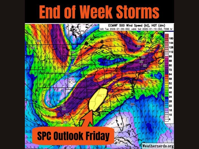
UNITED STATES – A pronounced dip in the jet stream is expected to take shape by the end of this week, setting the stage for storm chances across parts of Texas, Louisiana, Mississippi, Alabama, and Tennessee, while ushering in cooler air behind the system. Forecast models show an energetic upper-level pattern that could support organized storms, particularly on Friday, with some activity possibly extending into Friday night and Saturday.
Meteorologists are watching this setup closely because jet stream dips of this magnitude often act as a trigger for active weather across the South, especially when warm, moist air is already in place ahead of an advancing cold front.
Why the Jet Stream Matters This Week
The jet stream acts like a steering mechanism for storms, and this week’s forecast shows it diving unusually far south across the central and eastern United States. That dip creates a zone of strong wind energy aloft, which can help storms organize and intensify at the surface.
As the jet stream swings overhead, it also helps pull a surface system eastward, increasing the likelihood of widespread showers and thunderstorms across the highlighted states. Cooler air is expected to follow behind the system, marking a noticeable shift in temperatures after the storms move through.
Friday Is the Primary Day to Watch
The Storm Prediction Center’s outlook highlights Friday as the main window for storm potential, with parts of the lower Mississippi Valley and nearby regions under increased attention. While this is not currently signaling a major severe outbreak, the pattern supports stronger storms if conditions align.
Forecast guidance suggests storms could initially develop Friday before continuing eastward into Friday night and possibly early Saturday, expanding the time window for impacts.
Areas Most Likely to See Impacts
The region of concern stretches from eastern Texas into Louisiana, Mississippi, Alabama, and Tennessee, with storm chances potentially extending farther east depending on how the system evolves. These areas sit directly beneath the strongest part of the jet stream, where rising air and wind shear are most favorable.
Residents in these states could experience periods of heavy rain, gusty winds, and thunderstorms, especially during the late-week timeframe.
What Happens After the Storms
Behind the system, cooler and drier air is expected to filter in, bringing a break from the unsettled pattern. Temperatures should trend lower heading into the weekend, offering a brief reset after the storms pass.
Bottom Line
The end of the week is shaping up to be active across the southern United States, driven by a strong jet stream dip and a passing storm system. While details are still coming into focus, Friday stands out as the day most likely to bring impactful weather.
Do you think this setup delivers just rain, or could storms pack more punch than expected? Share your thoughts and stay weather-aware with updates from FatCityFeed.com.