Severe Thunderstorm Threat Targets Southern Plains and Mississippi Valley With Tornadoes, Hail, and Damaging Winds Possible Thursday
UNITED STATES – A growing severe weather threat is taking shape for Thursday, January 8, as forecasters warn that parts of the Southern Plains and Mississippi Valley could see damaging winds, large hail, and isolated tornadoes as a powerful storm system moves across the region.
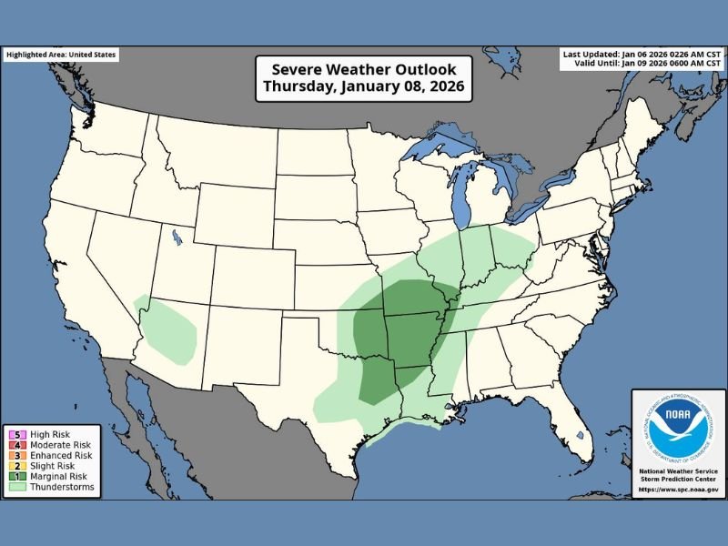
The latest severe weather outlook highlights a broad zone stretching from Texas and Oklahoma into Arkansas, Missouri, and surrounding states, where atmospheric conditions are expected to become increasingly favorable for strong thunderstorms. While the risk is not widespread nationwide, the areas highlighted could see fast-changing and potentially dangerous conditions.
Areas Facing the Highest Storm Risk
According to the outlook, the core threat zone covers portions of eastern Texas, Oklahoma, Arkansas, Missouri, and parts of the lower Mississippi Valley. These areas fall under marginal to slight risk categories, meaning scattered severe storms are possible rather than a continuous outbreak.
Communities within this zone may experience brief but intense storms, capable of producing wind gusts strong enough to down trees or power lines, along with hail large enough to damage vehicles and roofs.
Tornadoes Cannot Be Ruled Out
While widespread tornado activity is not expected, forecasters caution that a couple of tornadoes are possible, especially in storms that become isolated and rotate. Even a brief or weak tornado can cause significant damage, particularly in rural areas or places caught off guard.
Tornado potential is expected to increase during the afternoon and evening hours, when atmospheric instability peaks and storms gain strength.
Timing and Storm Development
Storms are expected to develop and intensify Thursday afternoon into the evening, with activity shifting eastward as the system progresses. Some storms may initially form as clusters before breaking into individual cells capable of producing severe weather.
Because these storms may move quickly, warnings could be issued with little lead time, making situational awareness critical for anyone in the affected areas.
Why This Setup Matters
This system is notable because it combines strong wind energy, moisture, and temperature contrasts, which can rapidly turn ordinary thunderstorms into severe ones. Even locations that avoid tornadoes could still see dangerous straight-line winds or sudden hail bursts.
January severe weather is not unheard of, but events like this often catch people off guard because many associate tornado season with spring, not mid-winter.
What Residents Should Do
People across the Southern Plains and Mississippi Valley are urged to monitor forecasts closely, review severe weather plans, and be ready to seek shelter if warnings are issued. Mobile alerts, weather radios, and local updates will be especially important as storms develop.
Do you live in one of the highlighted risk areas, and are you prepared if storms turn severe? Share your thoughts and stay connected with the latest updates at FatCityFeed.com.