North Carolina, Virginia, Tennessee, and the Mid-Atlantic Likely Stay Snow-Free Until Mid-January as Winter Pattern Delays
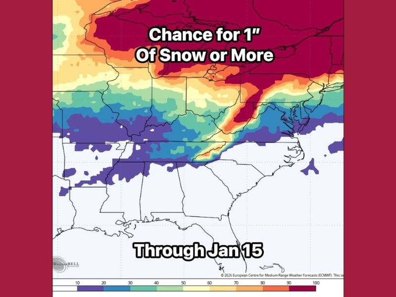
UNITED STATES – For much of the Southeast, winter lovers may need to stay patient. The latest long-range data from the European weather model indicates very little to no meaningful snow potential through mid-January, with the best odds confined to western North Carolina and areas farther north.
The blended European AI model run, which combines 51 ensemble simulations, continues to suppress snow chances across most of North Carolina, South Carolina, Georgia, Alabama, and much of Tennessee through at least January 15. While colder air is not completely absent, the overall weather pattern remains unfavorable for widespread winter storms across the region.
Where Snow Chances Actually Exist Right Now
According to the probability map, the highest chance for one inch of snow or more remains focused over:
- Western North Carolina
- Portions of Virginia
- Areas north of the southern Appalachians
Even in those locations, the signal favors higher elevations, not lowland cities. For central and eastern North Carolina, snow odds remain extremely low through the first half of January.
South of that zone — including South Carolina, Georgia, Alabama, and most of Mississippi — probabilities drop sharply, indicating a pattern that simply does not support winter weather in the near term.
Why Winter Is Being Pushed Back
Meteorologists point to a persistently mild upper-air pattern that keeps true Arctic air locked well north of the Southeast. While short-lived cold fronts may pass through, they lack the depth and timing needed to interact with storm systems in a way that produces snow.
In simple terms, cold air and moisture are failing to arrive at the same time.
The model guidance suggests that this setup holds steady until at least mid-month, keeping temperatures relatively mild and limiting winter precipitation to rain in most areas.
Signs of a Shift After January 15
While the near-term outlook looks quiet, forecasters are starting to see early signals of change beyond mid-January. The European model shows:
- Cold air becoming more frequent
- A more active storm track
- Increased potential for winter systems later in the month
At this point, there is no specific storm locked in, but the background pattern begins to look more supportive of winter weather after January 15. That’s often how meaningful winter setups begin — with subtle signals appearing well before individual storms show up on the maps.
What This Means for the Southeast
For now, residents across the Southeast can expect:
- Continued mild conditions
- Minimal snow threats
- Rain as the dominant winter precipitation type
Winter weather enthusiasts may be disappointed in the short term, but the data suggests that late January could become far more interesting, especially if colder air begins to align with incoming storm systems.
Bottom Line
Snow chances remain low across most of North Carolina and the Southeast through mid-January, with winter confined mainly to higher elevations farther north. However, signs are emerging that winter may finally find its footing later in the month.
Do you think late January finally delivers snow to the Southeast, or does winter stay stubbornly quiet? Share your thoughts and follow the evolving forecast at FatCityFeed.com.