North Carolina Sees Foggy, Cloud-Heavy Tuesday With Mild 50s and 60s as Clearing Struggles Statewide
NORTH CAROLINA – Tuesday is shaping up to be a foggy, cloud-dominated wildcard day across North Carolina, with visibility issues this morning, lingering cloud cover through much of the day, and temperatures heavily dependent on how much clearing actually occurs.
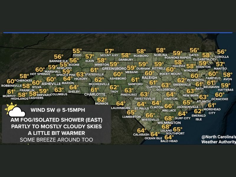
Forecasters say areas of fog — some widespread — developed early, especially during the morning commute, and while some improvement is expected, conditions may be slow to fully clear. The atmosphere is caught in between systems, leaving North Carolina without a strong push to completely sweep clouds and fog out.
Why Fog and Clouds Are Lingering Today
High pressure centered near Bermuda is beginning to build toward the Southeast, but meteorologists note it is not yet strong enough to fully take control of North Carolina’s weather. That weak steering flow allows moisture to linger near the surface, making it harder for fog and low clouds to clear quickly.
As a result, skies are expected to remain partly to mostly cloudy across much of the state, with only gradual and uneven clearing as the day goes on. Some locations may brighten up briefly, while others stay gray well into the afternoon.
Temperatures Depend on Clearing
High temperatures today are closely tied to how much sunshine breaks through. Most areas across North Carolina are expected to reach the mid to upper 50s, with low to mid 60s possible, especially in spots that see more prolonged clearing.
Some computer models suggested temperatures 3 to 5 degrees warmer statewide, but forecasters have expressed caution, noting that persistent cloud cover could limit warming in many areas. In short, places that clear out sooner may feel noticeably warmer than nearby towns that remain under clouds.
Regional Snapshot Across the State
Western and mountain areas are generally expected to remain in the mid to upper 50s, while the Piedmont and Sandhills trend closer to the upper 50s and low 60s. Coastal and southeastern communities stand the best chance of touching the mid to upper 60s, particularly if fog clears earlier in the day.
Winds are expected to stay light from the southwest, generally 5 to 15 mph, adding a mild feel but not enough to scour out cloud cover quickly.
What Comes Next
Despite today’s uncertainty, milder weather is expected to continue for the next several days, with no major cold air intrusions immediately on the horizon. While Tuesday may feel gloomy at times, it’s part of a broader trend toward more seasonable and comfortable conditions.
For now, drivers should remain cautious during foggy periods, and residents may want to keep layers handy as temperatures fluctuate throughout the day.
Did fog slow you down this morning, or did your area clear out faster than expected? Share your experience and keep the conversation going at FatCityFeed.com.


