New York’s Lake Effect Machine Fires Back Up as Rochester and Oswego Face Another Round of Accumulating Snow
ROCHESTER, NEW YORK – Just days after a major snowstorm buried large portions of the Northeast, parts of western and central New York are once again bracing for additional snowfall, this time from a more localized but persistent lake effect setup tied to Lake Ontario.
Forecasters stress that this is not another widespread snowstorm, but rather a series of on-and-off lake effect snow bands that could still add up over time, especially in communities east of Rochester and along Route 104 toward Oswego.
Lake Effect Bands Set to Shift Back and Forth Through the Week
Forecast guidance shows lake effect snow bands dipping southward overnight before lifting north again Wednesday. Another wind shift is expected to shove the bands back onshore Thursday and Friday — with a chance they linger into Saturday as well.
Unlike a classic single-band lake effect event, this setup will feature frequent repositioning, meaning snowfall won’t be constant but will come in bursts that gradually accumulate.
“It’s going to be a lot of back-and-forth rather than one steady band, but each round will add something.”
Who Could See the Most Snow
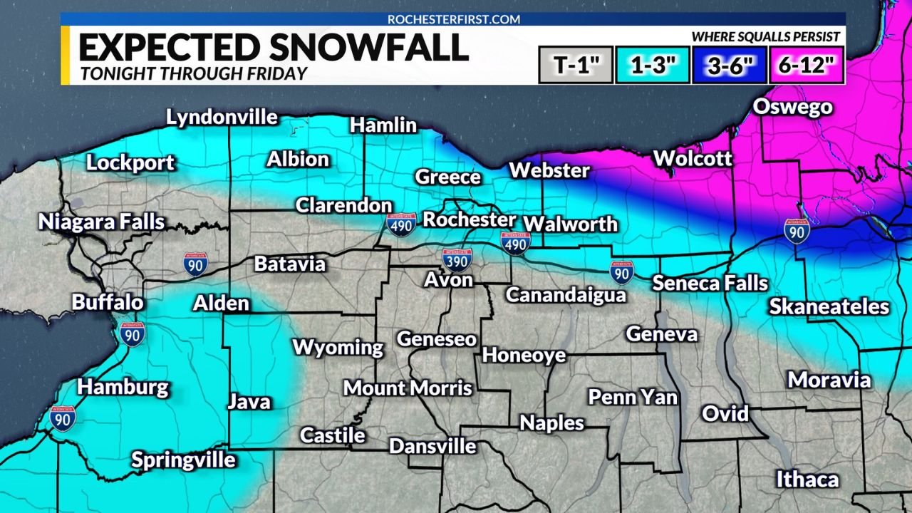
Snowfall projections through Friday show:
- 1–3 inches for much of the Rochester metro area
- 3–6 inches east of the city, including Webster, Walworth, and Seneca Falls
- 6–12 inches possible where lake effect squalls persist longest, especially near Oswego County
Even areas that miss the core band may still pick up nuisance accumulations that complicate travel during morning and evening commutes.
Why Lake Ontario Is the Main Player — and Lake Erie Isn’t
One key detail limiting how extreme this event becomes: Lake Erie is largely frozen, effectively shutting down its lake effect potential.
Lake Ontario, however, remains open and active — allowing cold air passing overhead to generate snow bands that continue to feed moisture into central and western New York.
This is why areas south and east of Rochester remain the primary focus, while traditional Lake Erie snowbelts are seeing far less activity.
Travel and Visibility Concerns Remain
Even modest snowfall totals can quickly become problematic under lake effect conditions, where visibility can drop rapidly inside heavier squalls.
Drivers are urged to be cautious, particularly along I-90, Route 104, and secondary roads east of Rochester where conditions can change mile by mile.
Officials remind residents that lake effect snow is notoriously unpredictable, and even short-lived bursts can create slick roads and whiteout conditions with little warning.
Another Reminder That Winter Isn’t Done Yet
For many across New York, this latest round of snow is a reminder that winter’s not finished, even after a major storm has already passed.
While this event won’t rival recent historic snowfalls, its persistent, localized nature means some communities could still end the week with a noticeably deeper snowpack.
Are you seeing lake effect snow where you live, or has your area dodged the bands again? Share your updates and join the conversation at FatCityFeed.com.