New York and New Jersey Under Cold Weather Advisory as NYC, Nassau County Face Dangerous Wind Chills Near −5°
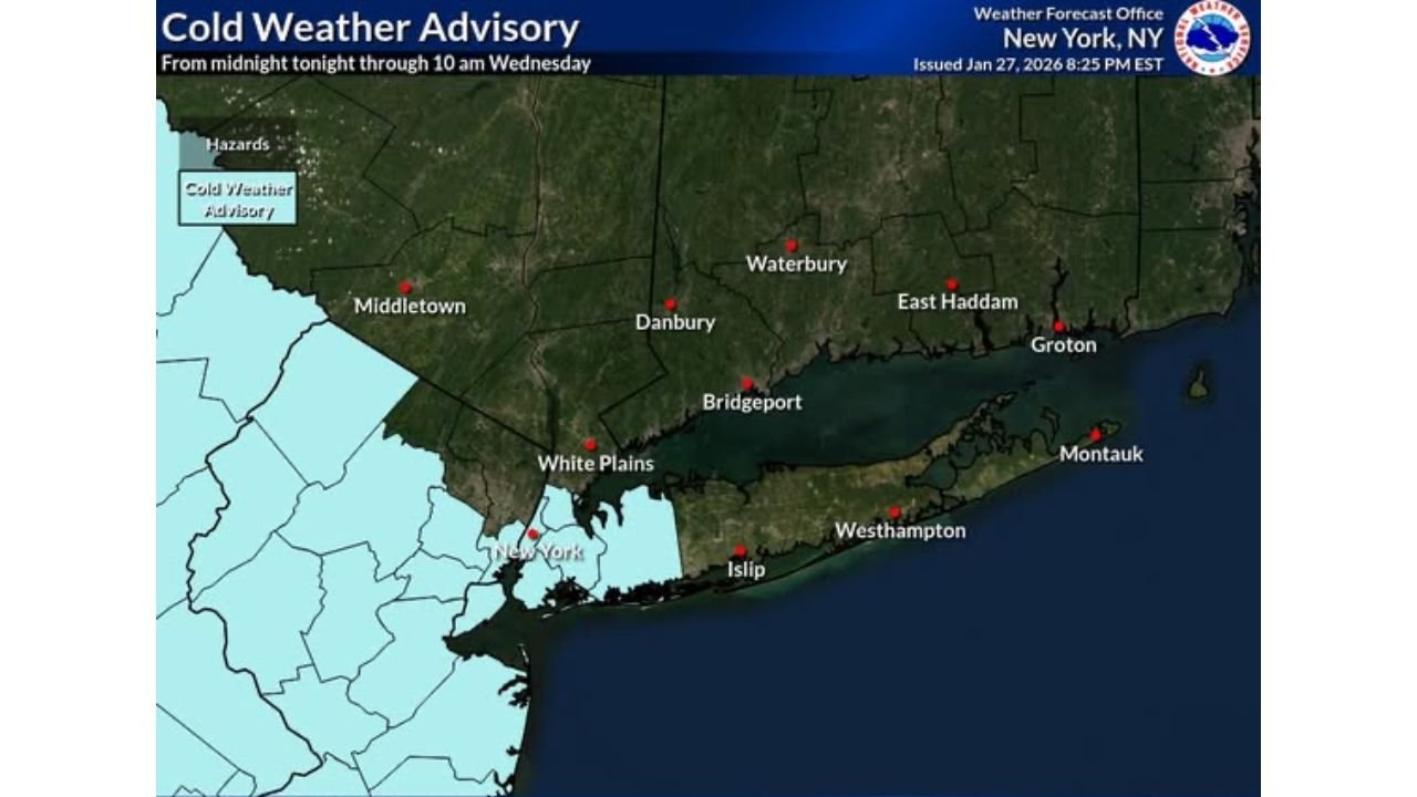
NEW YORK CITY, NEW YORK – A Cold Weather Advisory is in effect for New York City, Nassau County, and portions of northeast New Jersey from midnight through 10 a.m. Wednesday, as a surge of Arctic air pushes wind chill values down to around −5 degrees, creating dangerous conditions for anyone exposed to the cold.
Forecasters warn that while actual air temperatures will already be frigid, gusty winds will dramatically worsen how cold it feels, increasing the risk of frostbite and hypothermia — especially for those without adequate shelter or protection.
How Cold Will It Feel — And Where It’s Worst
Wind chill maps show some of the harshest conditions focused across:
- New York City, including Manhattan, Brooklyn, Queens, the Bronx, and Staten Island
- Nassau County on Long Island
- Northeast New Jersey, including areas near Newark, Jersey City, and Paramus
During the overnight hours into early Wednesday morning, many neighborhoods could briefly experience wind chills between −3° and −6°, with coastal areas seeing slightly higher values due to marine influence — but still well below safe comfort levels.
“These are the kind of wind chills where exposed skin can become numb quickly,” forecasters cautioned.
Why This Advisory Matters More Than It Sounds
Cold Weather Advisories don’t always grab attention like blizzards or ice storms, but experts stress that cold-related illness can be just as dangerous — and sometimes more deadly.
At wind chills near −5°:
- Frostbite can develop on exposed skin in as little as 30 minutes
- Hypothermia risk increases rapidly without layered clothing
- Vulnerable populations face elevated danger even with short exposure
Emergency officials urge residents to treat this advisory seriously, especially during early morning commutes when temperatures and wind chills will be at their worst.
Who Is Most at Risk Right Now
Health officials are urging extra caution for:
- Older adults, especially those living alone
- Young children, who lose body heat faster
- People without stable housing
- Outdoor workers and early-morning commuters
Residents are encouraged to check on elderly neighbors, relatives, and anyone who may not have reliable heat or winter clothing.
What You Should Do If You’re Heading Outside
Officials recommend several key precautions during the advisory window:
- Dress in multiple loose-fitting layers
- Cover all exposed skin, including face, ears, hands, and neck
- Wear mittens instead of gloves when possible
- Use water-resistant boots to prevent heat loss through feet
- Limit time outdoors and take breaks in warm areas
If you notice numbness, tingling, or pale skin, get indoors immediately — those are early warning signs of frostbite.
Cold Lingers Beyond Wednesday Morning
While the advisory is scheduled to expire at 10 a.m. Wednesday, cold air will remain locked in across the region, keeping daytime highs well below seasonal averages and setting the stage for continued chilly nights.
Meteorologists say additional advisories or warnings are possible later this week if wind speeds increase again or overnight temperatures drop further.
A Reminder That Winter’s Grip Isn’t Loosening Yet
This latest advisory is another reminder that winter hazards don’t always come with snowstorms. Even without falling precipitation, cold and wind alone can pose serious risks, particularly in dense urban areas where many people are exposed during commutes.
Are you feeling the cold where you live, or are you staying bundled indoors? Share how you’re getting through the deep freeze and join the conversation at FatCityFeed.com.