Back-to-Back Colorado Winter Storms Set Up Prolonged Mountain Snow, Sharper Cold, and Uncertain Plains Impacts
COLORADO – A complex winter weather pattern is taking shape across Colorado as two consecutive snowstorms move into the region, setting up several days of mountain snowfall, sharply colder temperatures, and growing uncertainty for communities east of the Continental Divide.
Unlike a single fast-moving system, these storms will arrive back-to-back, making it harder to pinpoint exact snowfall timing and totals, especially for foothill areas, the I-25 corridor, and the eastern plains. Forecasters say the overall message is clear: winter is tightening its grip, even if the details are still being refined.
Why This Weather Pattern Is So Tricky
Meteorologists describe this setup as unusually complicated. The first storm moves through on Thursday, followed closely by a stronger second system Thursday night into Friday. Because the systems overlap, snowfall may come in waves rather than a clean start and stop.
The second storm is expected to bring a stronger cold front and better upslope flow, which can dramatically increase snowfall in favored areas while leaving others with mostly cold air and lighter snow.
Mountain Snow Timing and Duration
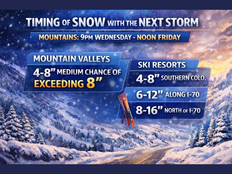
Snow is expected to begin in the mountains late Wednesday night, continuing through Friday midday. That long window increases the potential for meaningful accumulation, even if snowfall rates vary.
Extended-duration events like this often produce higher totals than initially expected, particularly when colder air arrives midway through the storm cycle.
Expected Snowfall at Ski Resorts and Valleys
Confidence is highest in the mountains and ski country. Forecasts call for 4 to 8 inches in mountain valleys, with a moderate chance of totals exceeding that range.
Ski resorts could see:
- 4 to 8 inches in southern Colorado
- 6 to 12 inches along the I-70 corridor
- 8 to 16 inches north of I-70
Winter Park already reported 6 inches of fresh snow overnight, signaling that this pattern is capable of delivering real accumulation.
What This Means for the Plains and Foothills
East of the Divide, impacts are less certain. Communities along I-25, eastern Colorado, Wyoming, Nebraska, and western Kansas may see snow, but timing and amounts depend on how quickly cold air moves in and whether upslope winds develop.
Some locations could end up with light snow and bitter cold, while others may see more meaningful accumulation if conditions align.
Bottom Line
Colorado is entering a multi-day winter stretch marked by colder air and steady mountain snow. While the mountains will benefit most, everyone should stay alert as small shifts could significantly change impacts farther east.
Do you think this second storm will overdeliver or underperform for the plains? Share your thoughts and join the discussion at FatCityFeed.com.